


Agrandissement
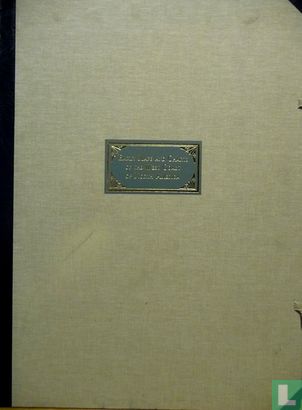
Early maps and charts of the west coast of North America


Descriptif de l'objet
Numéro LastDodo
3288785
Catégorie
Cartes géographiques des pays et globes
Titre
Early maps and charts of the west coast of North America
Type
Fabricant / Éditeur
Pays de publication
Cartographe / dessinateur
Année
1985
Édition
Collection
Numéro dans la collection
351
Numéro complémentaire
Échelle
Continent
Zones non indépendantes
Anciens pays et colonies
Région / province
Ville
Matière
Coloration
Langue / dialecte
Thème
Dimensions
59 x 78
ISBN13
ISBN10
Particularités
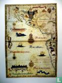
# 351 sur 500. Les premières cartes et cartes de la côte ouest de l'Amérique du Nord sur l'histoire des cartes et des cartes marines, des cartographes et des éditeurs et certaines périodes de l'histoire américaine. Le livret d'accompagnement de 32 pages fournit une introduction et des détails complets sur chaque carte. Publié en édition limitée à 500 exemplaires. Les cartes et graphiques du portefeuille sont des reproductions des originaux des collections des musées et bibliothèques. Ils ont été imprimés sur "Hollands luxe koperdruk" sur les presses de BV Kunstdrukkerij Mercurius-Wormerveer, Pays-Bas.
Ce texte a été automatiquement traduit du Anglais
Cliquez ici pour le texte original
# 351 of 500.
Early maps and charts of the west coast of North America on the history of maps and sea charts, cartographers and publishers and some periods of American history.
The 32 page accompanying booklet provides an introduction & full details on each map.
Publishied in a limited edition of 500.
The maps and charts in the protfolio are reproductions of the originals in the collections of the museums and libraries. They were printed on "Hollands luxe koperdruk" on the presses of BV Kunstdrukkerij Mercurius-Wormerveer, The Netherlands.