Agrandissement
Geologische kaart van Nederland 1:50.000. Blad 46 Vierlingsbeek, Kwartblad I

Descriptif de l'objet
Numéro LastDodo
5731913
Catégorie
Cartes géographiques des pays et globes
Titre
Geologische kaart van Nederland 1:50.000. Blad 46 Vierlingsbeek, Kwartblad I
Type
Fabricant / Éditeur
Pays de publication
Cartographe / dessinateur
Année
1935
Édition
Collection
Numéro dans la collection
Numéro complémentaire
Échelle
Continent
Pays
Zones non indépendantes
Anciens pays et colonies
Région / province
Ville
Matière
Coloration
Langue / dialecte
Thème
Dimensions
55x42 cm
ISBN13
ISBN10
Particularités
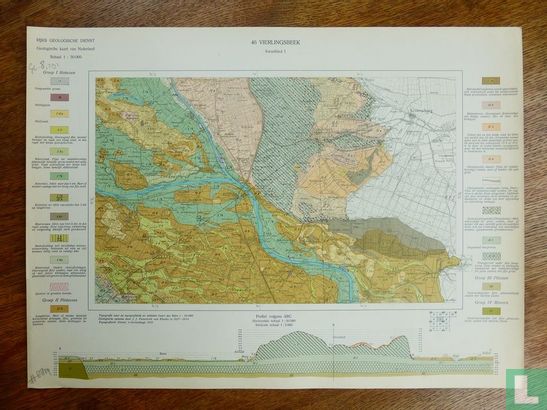
Carte géologique des Pays-Bas au 1: 50 000. Feuille 46 Vierlingsbeek Quarter sheet I. [Gassel - Groesbeek - Gennep area] 1935. National Geological Survey, levé géologique J.J. Pannekoek van Rheden 1927-34. 1x cartes dépliées avec profil, carte environ 40x55 cm, zone carte 25x40 cm.
Ce texte a été automatiquement traduit du Néerlandais
Cliquez ici pour le texte original
Geologische kaart van Nederland 1:50.000. Blad 46 Vierlingsbeek Kwartblad I. [gebied Gassel - Groesbeek - Gennep] 1935. Rijks Geologische Dienst, geologische opname J.J. Pannekoek van Rheden 1927-34. 1x ongevouwen kaarten met profiel, kaart ca. 40x55 cm, kaartoppervlak 25x40 cm.